Mapping Arda, Part I: Terraforming by Anérea
Posted on ; updated on
This article is part of the newsletter column Tolkien Fanartics.
I am sorry about the Geography. It must have been dreadfully difficult without a map or maps.1
I've been entranced by maps, plans, and cross-sections for as long as I can remember. As a young child I’d obsessively draw and redraw landmarks and routes through places both imagined and real, often doing the whole soaked-in-coffee-with-burned-edges thing that Tolkien did with his Book of Mazarbul pages. When I discovered mountaineering, I’d pore over maps for weeks before my journeys, and in the inevitable downer that came with returning from the mountains, my maps provided solace as I compared my routes with my memories. If a book featured a map—fiction or nonfiction—it received bonus points by default. I have never met a fan who does not appreciate Tolkien’s maps, whether for their narrative usefulness or their aesthetic appeal. They are such an integral part of the legendarium’s magic, and indeed his maps have been a foundational influence on modern fantasy maps in general.
In his email to me, cartographic artist Jamie White (whose work is featured below) wrote:
Maps were essential to the creation of Tolkien's legendarium. He drew them not only as aides for the reader in his published works, in forms which were extended and perfected by his son Christopher, but as aids to composition and conception in his private notes, in forms he never meant to be published. I discovered when researching the maps and plans I've made around Tolkien's work that if you know his maps, then reading the stories feels completely different. You can track the narrator's eye as it roves over the face of a spatially coherent geography.
The varying purposes of Tolkien’s maps mean that some are remarkable in their attention to detail while others are vague, albeit tantalising, sketches. There is a certain magic about mapping Arda, making the world just a touch more real. Over the decades many fans have redrawn and embellished Tolkien's maps, frequently referencing The Atlas of Middle-earth by Karen Wynn Fonstad or filling in the blanks with interpretations drawn from painstaking extrapolations of the canon. By their very nature, fan-made maps vary widely from faithful interpretations to creative reimaginings.
This four-part series is a celebration of some of these fan-made renderings, and I also hope it will serve as a useful resource for fans in visualising the canon and as well as inspiration for future fanworks. Part I features the shaping of Arda, the formative years prior to the War of the Gods, as well as Valinor and the lands of Aman. Thereafter I will present the maps in in-universe chronological order—as far as this is possible since there are often overlaps—covering Beleriand, Númenor, and Middle-earth during the Second and Third Ages, before exploring the wider, lesser-known lands to the east and south.
Where I reference Tolkien’s original maps and diagrams I have included links to the relevant pages on Tolkien Gateway where they may be viewed.
Ambarkanta: Shape of the World
And suddenly the Ainur saw afar off a light, as it were a cloud with a living heart of flame; and they knew that this was no vision only, but that Ilúvatar had made a new thing: Eä, the World that Is.2
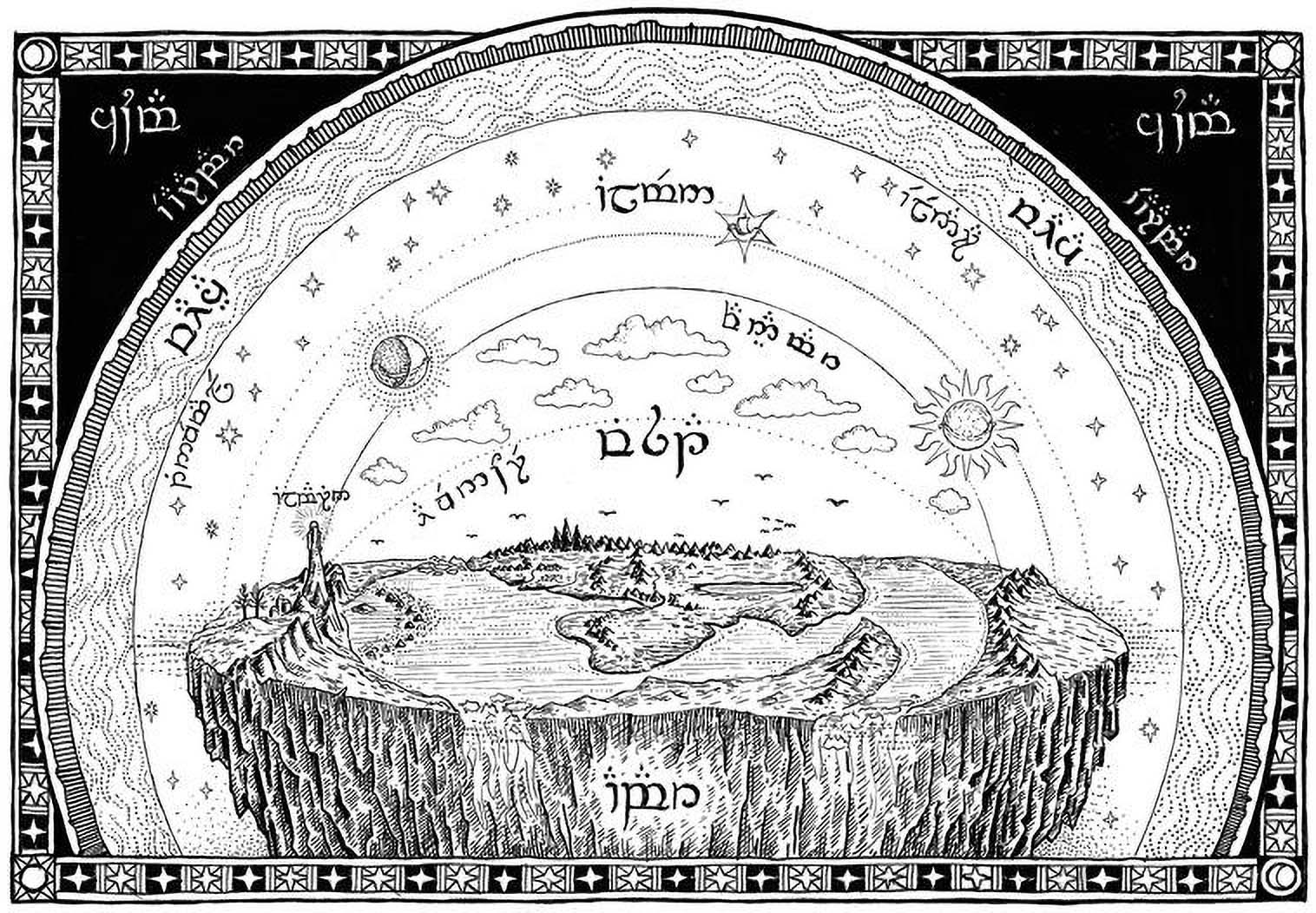
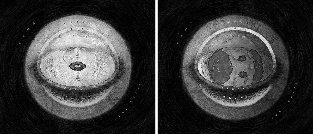
Not satisfied with merely designing a new land and seas, Tolkien devised an elaborate atmosphere for Arda too. So after drawing his first "Silmarillion" map of Beleriand, it was natural that he sketch cross-sections of his world too. The Ambarkanta diagrams and maps3 illustrate the form of Arda—essential visual references for a world with such unique terrestrial and atmospheric properties. Diagram I and Diagram II show the flat world in cross-section, from east to west and from north to south, while Diagram III illustrates the round world after the Downfall of Númenor with the straight road to Valinor. Map IV and Map V show plan views of Arda during the Years of the Lamps and after the War of the Gods, respectively.
Of course, in the beginning there was nothing much to map. On their arrival in Arda at the dawn of Time, the Valar—expecting to find their Music made form as in the vision shown to them by Eru—were astonished and baffled to discover that it had in fact been nothing more than just that: a mere vision of the future. Arda was yet to be shaped and their real labours were only just beginning.
Like so much in The Silmarillion, this major event is condensed to a few lines and the full implications are easily overlooked. Yet while most fan maps focus on later Ages, Casei Solus came in at the same point as the Valar, creating the only vision of Arda I know of in its primordial state.
When I asked what inspired her, she replied: “Oh, I just saw the hand-drawn maps in The Silmarillion, and I was obsessed with map stuff at the time, so I wanted to try to see if I could make something realism-ish of it on Photoshop.” Although she went on to modestly describe it as “fancier tracing of the original maps with photo bashing”, her choice of rendering is not only aesthetically unique. One is given a strong sense of the rawness the Valar faced on their arrival, while the translucency of the dome provides a three-dimensional quality to the atmosphere.
She suggests it's a bit bright, but I’d say no more so than our modern false-colour photographs of deep space. In any case the Valar may well have the ability to see nonvisible parts of the electromagnetic spectrum, so this could just as easily be a representation of how they perceived it.
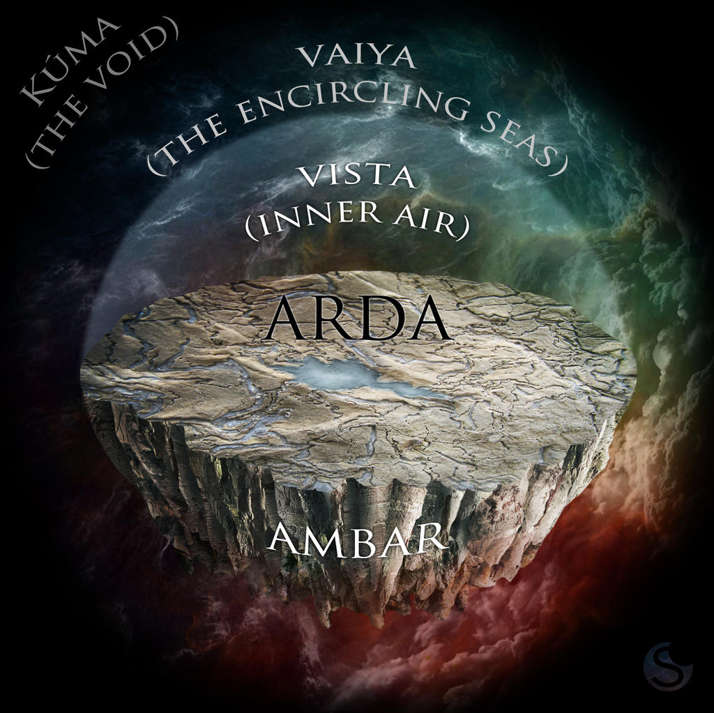
Matej Cadil, a traditional artist and illustrator from Prague for whom Tolkien is a great love and inspiration, responded to an Inktober prompt “layers" with his stylised version of The Ambarkanta, cleverly combining the different layers of atmosphere from Diagram I with the lands shown in Map V.
Labelled in Tengwar, above the bulk of Ambar, the earth, the three layers of atmosphere are clearly delineated: within Eärambar, the “Walls of the World” is Vaiya, the “Enfolding Ocean”, the outermost layer consisting of a nebulous substance described as being “more like to sea below the Earth and more like to air above the Earth”.4 Next is Ilmen, the “Star-street”, the middle airs that also encapsulate the earth, wherein Varda hung the stars in the upper reaches and where the moon and sun traverse its lower regions. Ilmen is also the rarified air of both Valinor and the eastern continent on the opposite side of the world. Spanning from the eastern shore of Aman to the western shore of Easterness, Vista is the inner, breathable, air and is divided into Fanyamar, "Cloud-home", above and Aiwenore, "Bird-land", below. Beyond Vaiya lies Kúma and Ava-Kúma, the Inner and Outer Voids.
I Vene Kemen: Vessel of the Earth
“O Valar, ye know not all wonders, and many secret things are there beneath the Earth's dark keel.”5
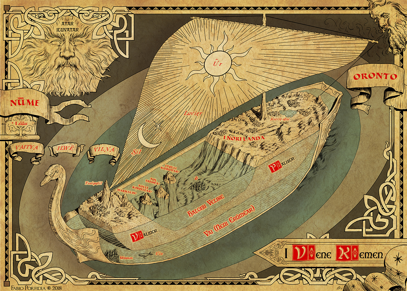
In one of Tolkien’s earliest sketches of Arda, I Vene Kemen,6 the world is depicted as a ship shown in cross-section, with land and sea floating upon Vai (the Outer Ocean), which in turn is cradled by the ship’s hull.
Drawn while writing The Book of Lost Tales, it contains some features that later changed, including a mysterious structure on the sea bed that Christopher suggests may possibly be Ossë’s home, although I can’t help wondering whether it pertained to his “Atlantis haunting” and presages drowned Númenor. The sun and moon on the sail is also highly out of kilter with the rest of the legendarium, and Christopher notes that the mast, sail, and curved prow appear to have been added afterwards, perhaps suggested by the shape of the Earth and Vai as his father had drawn them.7
Italian fantasy artist and art teacher Fabio Porfidia felt it was a pity that such a beautiful idea had never been refined to a proper illustration, and decided to re-create a personal version of this view of Arda while keeping as faithful as possible to the original design. Although created with digital media, his use of simulated pen and ink lends the drawing a classic feel well suited to the subject, while rendering it in this angle of view affords us an added sense of depth and placement of the features.
The Spring of Arda
And there upon the Isle of Almaren in the Great Lake was the first dwelling of the Valar when all things were young, and new-made green was yet a marvel in the eyes of the makers.8
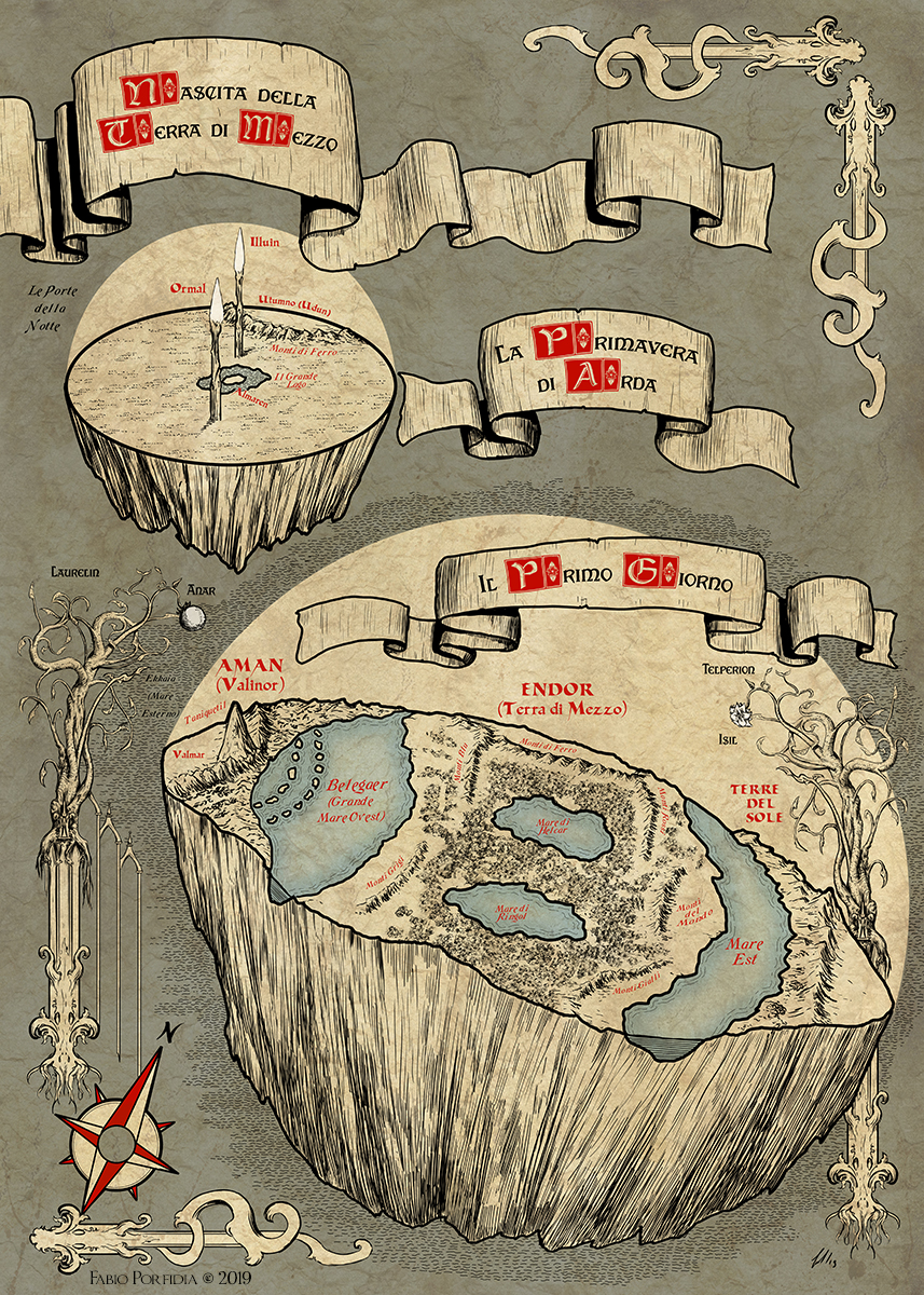
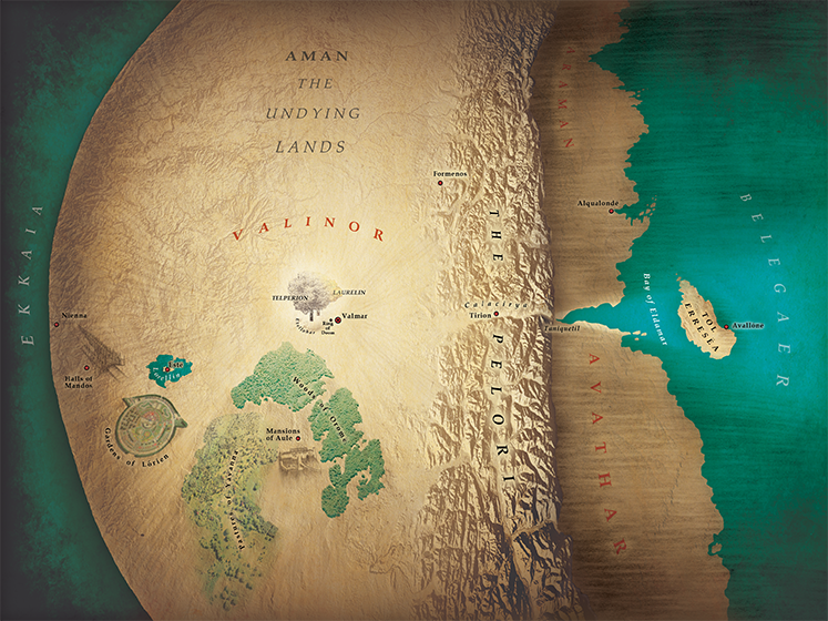
Considering that they had no precedent, we can perhaps forgive the Valar for being rather unimaginative in their initial ordering of the lands and sea, keeping everything all neatly symmetrical: a round island centred in a circular lake at the middle of the world. The two Lamps they built to illuminate it each mirrored the other, one to the north, one in the south, so that their light met and mingled at the centre.
While Melkor’s toppling of the Lamps ruined this perfection, some symmetry nonetheless remained, with the inland lake splitting in two, and two seas forming either side of the central continental landmass, all bracketed by the land of Aman (Valinor) to the west and the Eastlands or Easterness (labelled “Lands of the Sun” on Tolkien’s Fourth Ambarkanta map) on the opposite side.
Fabio Porfidia was also inspired to illustrate Arda during the years when the Valar dwelt upon the central isle of Almaren under the light of the lamps, as well as the lands as they appeared in the aftermath of the toppling until the War of the Gods. He says he took the aesthetic liberty of setting Laurelin and Telperion—which actually stand at the gates of Valmar, the city of the Valar in Valinor—outside of Arda in order to enhance them and also to evoke the concept of Sun (Anar, fruit of Laurelin) and Moon (Isil, flower of Telperion) and, ultimately, to provide a decorative frame for the drawing. [See image at top.]
UK artist and illustrator Jamie Whyte created some fabulous black and white drawings of this era too. He says he found his specialism in creative cartography pretty much by accident:
It was just a thing I was asked to do once, which came out pretty well, and which I was then asked to do again and again. The more maps I made though, the more I understood them as images that should combine beauty and utility in equal measure. J.R.R. and Christopher Tolkien’s maps of Middle-earth and Beleriand are perfect exemplars of this.
He further explains:
My main aim in making my versions of the maps was to add to them that unique and indescribable feeling of the reality of Tolkien’s legendarium, which I’m sure any other readers can relate to. There is an atmosphere of intense, bright immediacy that emanates from the pages of The Silmarillion, but which is also imbued with a sense of both historicity, and a kind of "legendariness"—of ancientness which feels alive. As a brightly sunlit scene viewed far-off through a palantír. That was the feeling I wanted to put into my maps.
Years of the Trees: Aman and Valinor
Behind the walls of the Pelóri the Valar established their domain in that region which is called Valinor; and there were their houses, their gardens, and their towers. In that guarded land the Valar gathered great store of light and all the fairest things that were saved from the ruin; and many others yet fairer they made anew, and Valinor became more beautiful even than Middle-earth in the Spring of Arda.9
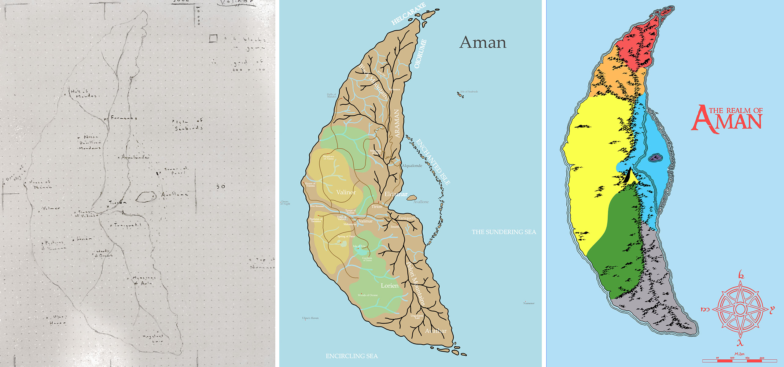
After the toppling of the Lamps and the utter ruin of Middle-earth, the Valar moved west to set up home in Valinor on the continent of Aman. The only visual references Tolkien gave us for these lands are the rough sketches of his two Ambarkanta maps, containing just a few major landmarks. As such fans have had to extrapolate locations for the rest from the various texts, and this has resulted in the widest range of cartographic interpretations. (Other than the lands to the east and south of Middle-earth, as we shall see in Part IV.
Jamie Whyte created his own interpretation of the Undying Lands in the form of a relief map, providing us with a good idea of the path of the light of the Trees through the Calacirya, and the immense height and steepness of the Pelóri Mountains.
Tolkien wrote in a letter that “I wisely started with a map, and made the story fit (generally with meticulous care for distances). The other way about lands one in confusions and impossibilities.”10
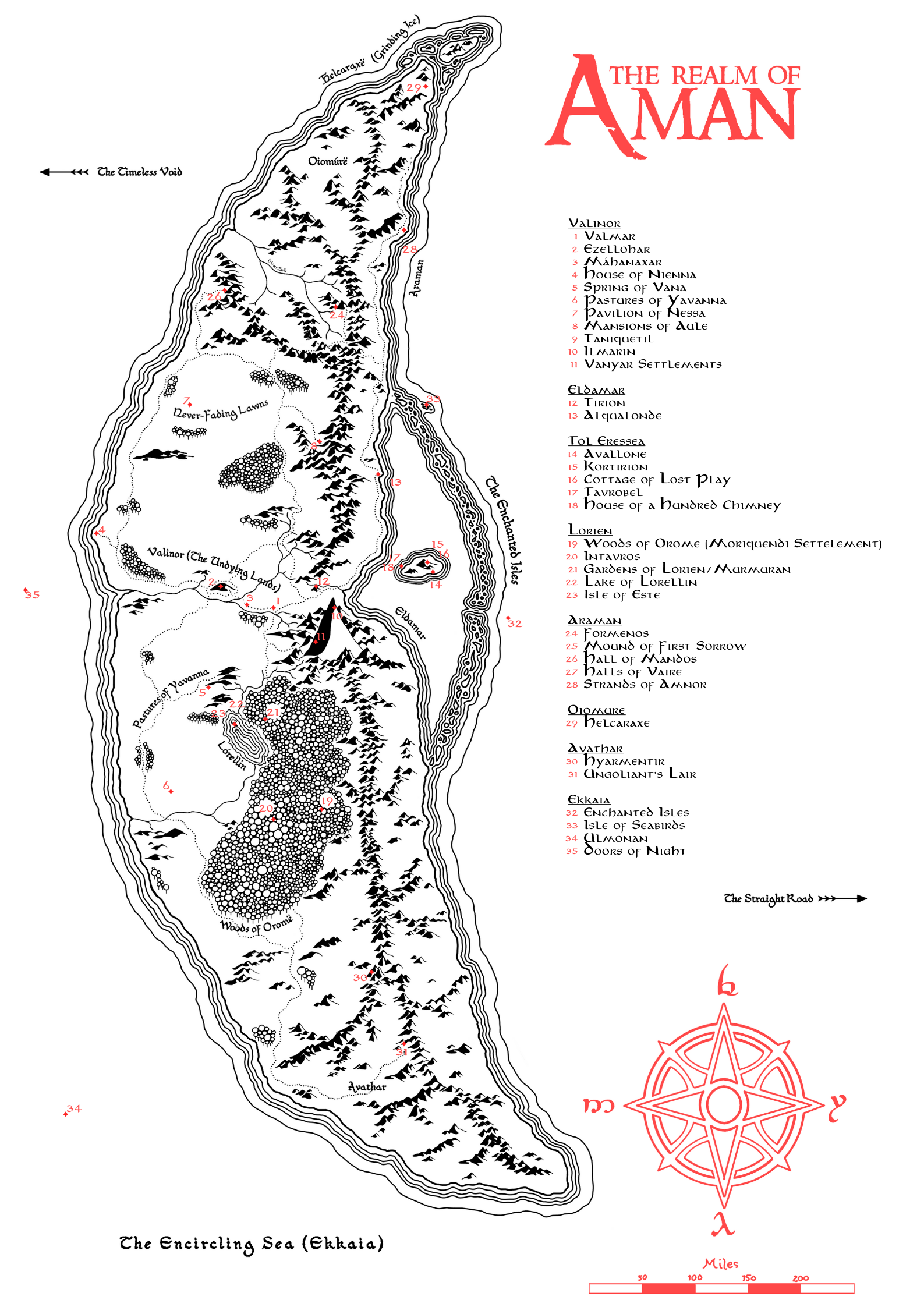
Nelman Black experienced the utility of this when he began work on The Aman Project as an aid to faithfully recreating the Undying Lands within Minecraft Middle-Earth. Starting with extensive research drawn from all parts of the legendarium, he soon found himself making a map as an easy way to understand how everything fitted together across the continent, ultimately providing a solid base upon which to lay out a believable world. He says:
From this I was able to make sense of a lot of things, first of which is the actual use of the area called Valinor. Many maps and people that I have consulted about this area have used Valinor interchangeably with Aman, with this map I have ultimately made the hierarchy more structured with Aman being the entire continent, Valinor the area west of the encircling mountains and Eldamar separate from “the Undying Lands” by the Calacirya rather than being classified as "the Undying Lands" as a whole. From this I was able to structure the remaining regions around this base.
Another example of this would be the fortress of the exiled Fëanor, Formenos, with many other depictions placing the location relatively close to the rest of the known areas of Aman. To me this didn’t seem like much of a punishment as the point of Fëanor being exiled was to remove him from causing trouble within Aman, so I moved Formenos outside of the encircling mountains that contain the region of Valinor and in turn meaning that we can populate the more northern sections of the map and add some variety to how the different peoples react, rather than the very centralised maps that are popular.
From this point the next big change was Aulë, whose court is said to be near to Valimar; to me this seemed strange as his character didn’t seem to fit this location. So with the knowledge of him having created much of the terrain/mountains of Arda and having made the Dwarves in secret from the other Valar and Eru, as well as having the style and culture of Dwarves being pulled from somewhere, a mountain hall seemed to fit better. Additionally placing him in proximity to the exiled Elves in the north helped connect the Noldorin Elves with their affinity for crafting and the relationship they had to him.
Nelman’s first version was a sketch with the general strokes in place but some big changes to what we see in the final map. He completed the layout in Photoshop, adding roads and rivers and finalising the mountain layout, at which point it occurred to him to make the map in the same style as Tolkien’s maps, so he redid the map entirely!
The result is a carefully researched interactive map of Aman that, like Tolkien’s published maps, could be said to have been created by someone within the world.
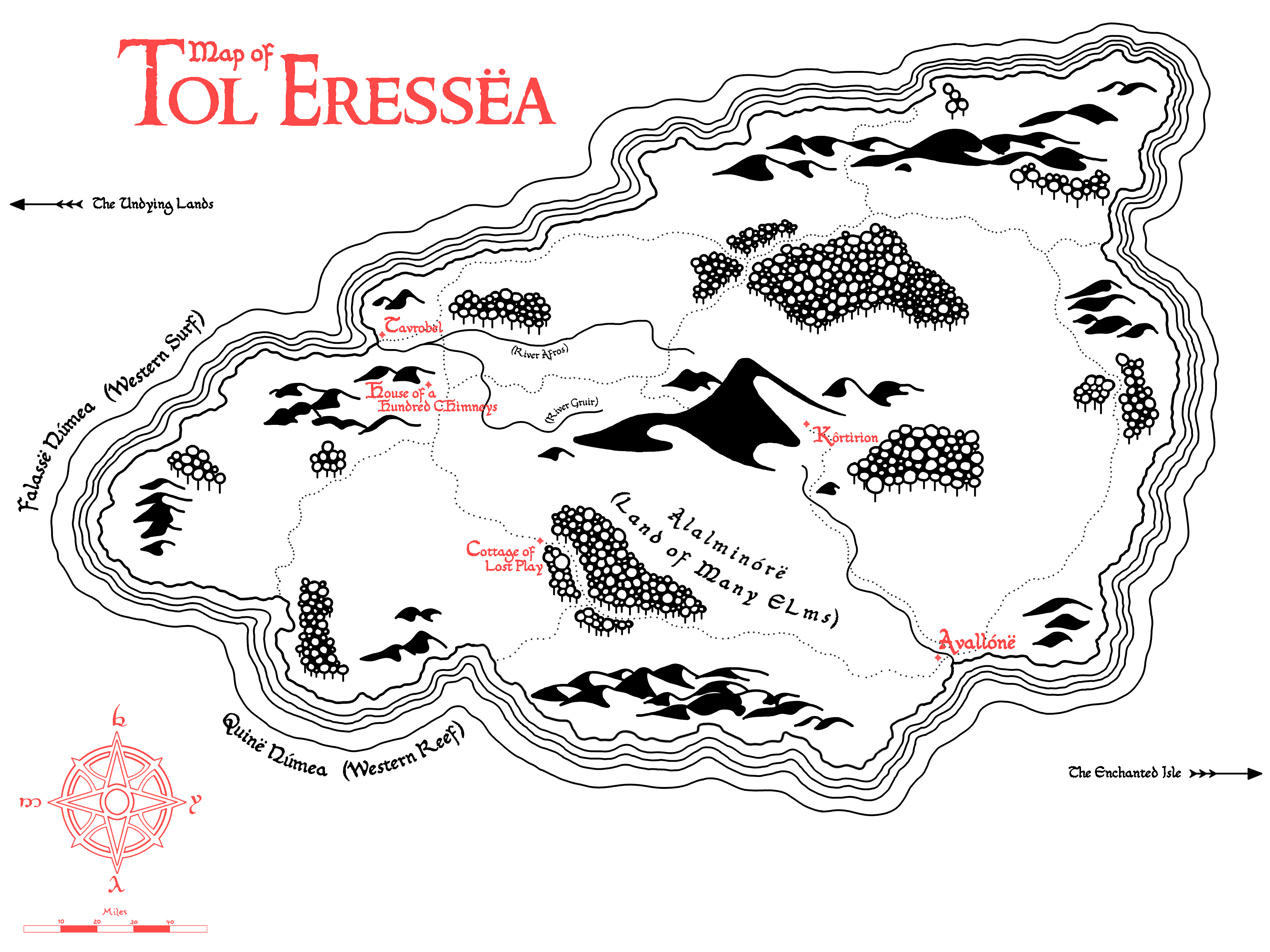
With the Aman map complete, a similar map of Tol Eressëa inevitably followed, spurred especially by the many locations on the island Tolkien gives us in earlier versions of the legendarium. “Without much need to change up the general shape of the island from Fonstad’s map,” Nelman says,
Tirion upon Túna
Upon the crown of Túna the city of the Elves was built, the white walls and terraces of Tirion.11
It was suggested to Bunn that she make a map of Tirion, so she did! And in the process quite likely put a lot more thought into realistic details than Tolkien did, resulting in this creative work of cartographic art.
Working with a mix of canon and rich headcanon grounded in practicality, she tells us:
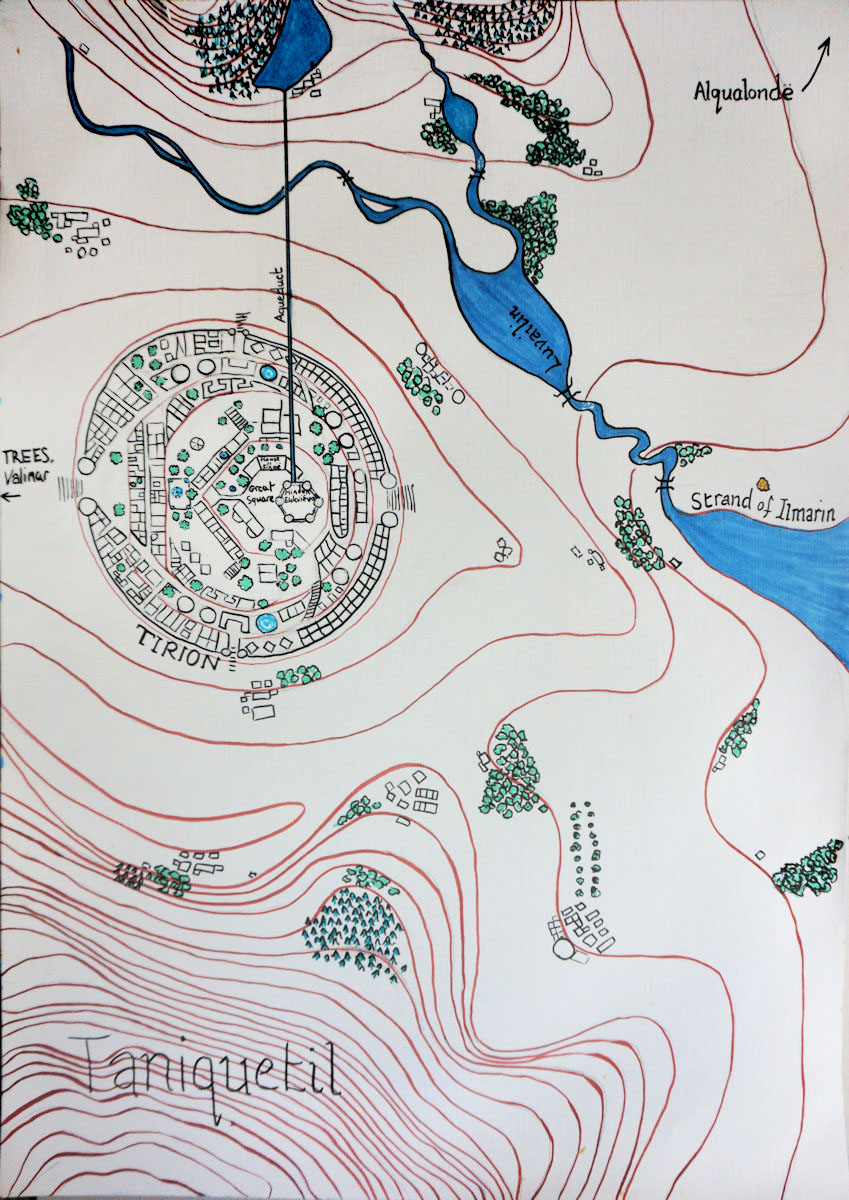
The Pelóri mountains lie to the north (I don’t think the mountain directly north of Tirion is named individually) and Taniquetil to the south, with the gap of the Calacirya between, and Tirion on a green hill in the middle of the pass. (If you think there aren’t enough buildings in Tirion, feel free to assume that many of the squares are tall apartment-houses, and also that the hill itself has been dug into, as well as built on. There are many surrounding farms and villages outside the walls.
Manwë of course lives on top of the mountain Taniquetil, in his mansion of Ilmarin. I think the Strand of Ilmarin east of Tirion is called that because if you stand on the shore and look up, you could see Ilmarin right at the top of the mountain, though there’s no way up directly from Tirion to Ilmarin, except for Eagles. You have to go around via Valimar if you are travelling on foot.
The city is built to take advantage of the light from the Trees with the main entrance to the west, though there is also a steeper winding route that goes up into the city from the Eastgate.
Tirion is supplied with water from a reservoir in the foothills of the Pelóri, via an aqueduct that runs to the great tower of the Mindon Eldaliéva, where Ingwë lived when he first came to Valinor. The large building with two wings next to it on the Great Square is the House of Finwë, built with Light-gardens to the west, and a Star-garden to the east.
When Finwë remarried, Fëanor moved out and got married himself. I think his house is one of the houses about halfway up the hill, conveniently located for access to the warehouses and workshops of the Fëanorian Quarter, clustered in the best light beside the gate.
In the Years of the Trees, the light in Tirion came from the west and slightly from the south, so that the lake of Luvailin, or Shadowmere, was always in the shadow of the hill, and the lights on the star-side of Tirion reflected in the water.
The excellent water pressure supplied by the aqueduct, among other things, powers the fountains and the water-wheels of Tirion, and the water drains through a tunnel down into the Shadowmere.
I’ve probably made the streams look too wide. I intended them to be minor watercourses, not large rivers. There are of course many bridges to allow easy access to Alqualondë, a little north and east right on the coast.
The City of Valmar
In the midst of the plain beyond the mountains they built their city, Valmar of many bells.12
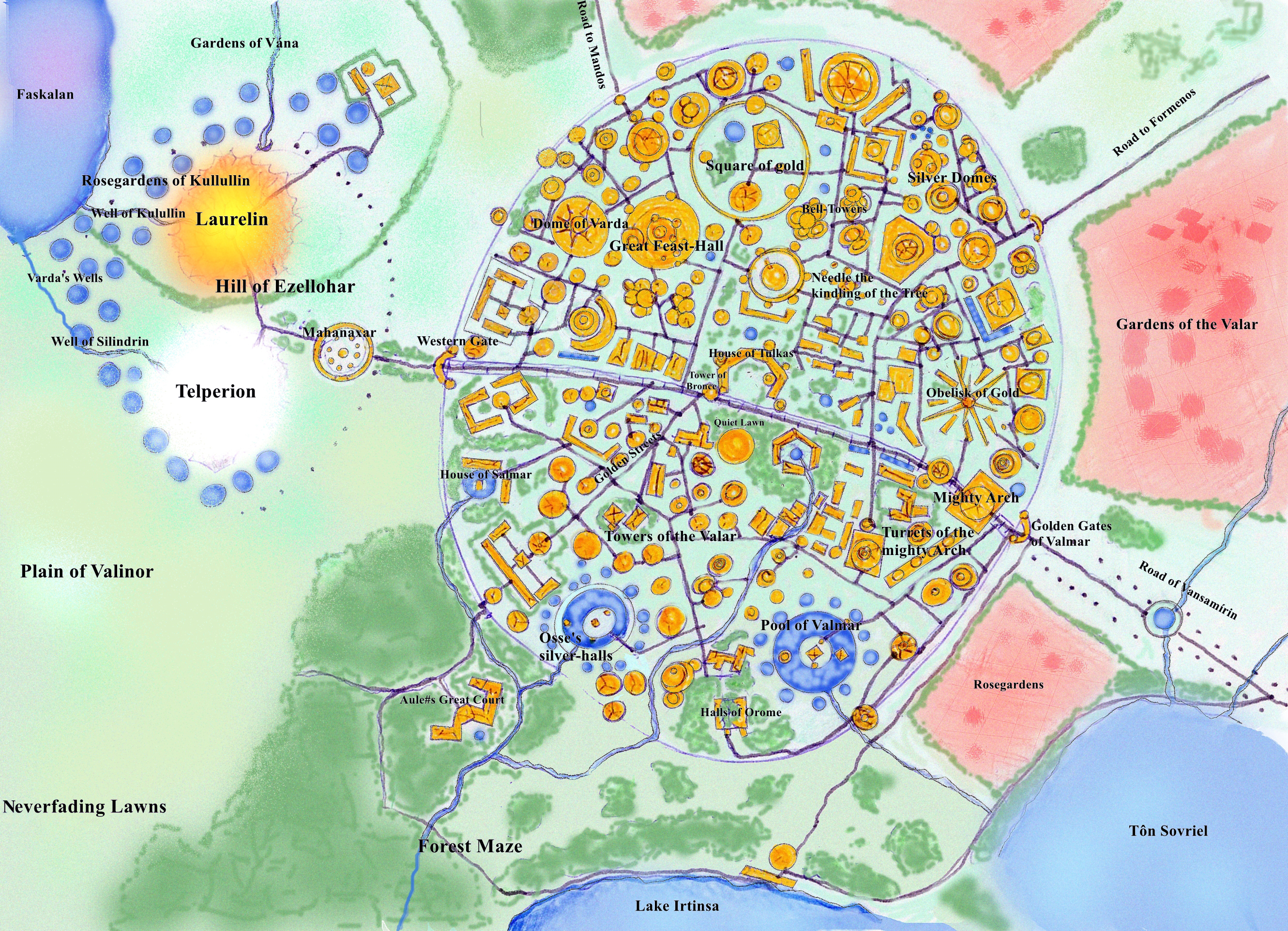
While Tolkien didn’t sketch a plan of the city of the Valar—and later the Vanyar—in Valinor, one may glean a fair few details about it from scattered mentions in the early chapters of The Silmarillion, although The Book of Lost Tales provides the most detailed descriptions.13
This imaginative map of the City of Bells was created for The New Notion Club Archives, an open project wiki dedicated to subcreation within Tolkien's world. Originally set up to preserve out-of-print and fan-made material for roleplaying games, it expanded to include the broader field of subcreation. As such, most of the content contains headcanons more than canon.
Utilising an unusual mix of traditional and digital media to create this city plan, the artist details many of the Valar’s houses, gardens, and other landmarks within the city and surrounds which were described by Tolkien, mingled with original fanonical places.
Conclusion to Part I
Jamie Whyte eloquently expressed what it is that charms and inspires us so much about Tolkien's maps:
Another part of what gives rise to that feeling of reality in Tolkien’s writing is the depth and breadth of his passion and expertise as a philologist, which has led me to see language as a kind of treasure hoard. The way Tolkien uses and crafts words, burnishing and regifting them from the deep past of our own language, reinforces this view: and the way his stories are presented alongside maps which are intrinsic to understanding them makes each volume seem like a treasure hoard in itself.
Maps lead you to treasure, and maps are themselves treasure.
The collection of maps in this series is very far from complete—I have found so many marvellous fan maps but had to make a small selection! There are very likely more “treasures” that I haven't stumbled on yet, so if you have your own maps, plans, or diagrams that you would like to share, or know of maps by other artists that may be of interest to others, please feel free to contact me. I’d love to hear from you!
I was unable to make contact with the artists of a few of the maps and artworks I particularly wished to feature, so I have shared links to their websites for your reference and enjoyment instead:
Beautiful pictorial maps of Aman, Númenor and, Middle-earth, as well as a coloured Ambarkanta diagram by Jacques Calvreul
A whimsical antique-style map of Aman by Amegusa
Timeline and maps of early Arda by Criti420
A spectacular photorealistic rendering of the Ambarkanta by Gordon Theobold
Works Cited
- Letters by J.R.R. Tolkien, "144 to Naomi Mitchison."
- The Silmarillion, Ainulindalë.
- The History of Middle-earth, Volume IV: The Shaping of Middle-earth, The Ambarkanta.
- The History of Middle-earth, Volume I: The Book of Lost Tales, Part One, The Hiding of Valinor.
- Ibid.
- The History of Middle-earth, Volume I: The Book of Lost Tales, Part One, The Coming of the Valar and the Building of Valinor, "Notes and Commentary."
- Christopher Tolkien notes in The Coming of the Valar and the Building of Valinor: “[C]lose examination of the original drawing strongly suggests to me that the mast and sail, and still more clearly the curved prow, were added afterwards. Can it be that the shape of the Earth and of Vai as he had drawn them—with the appearance of a ship's hull—prompted my father to add mast, sail, and prow as a jeu d'esprit, without deeper significance? That seems uncharacteristic and unlikely, but I have no other explanation to offer. If this is so, and if I Vene Kemen means 'The Earth-Ship', then this title must have been added to the drawing at the same time as the mast, sail, and prow.”
- The Silmarillion, "Of the Beginning of Days."
- Ibid.
- Letters by J.R.R. Tolkien, "144 to Naomi Mitchison."
- The Silmarillion, “Of Eldamar And The Princes Of The Eldalië.”
- The Silmarillion, "Of the Beginning of Days."
- The History of Middle-earth, Volume I: The Book of Lost Tales, Part One, The Hiding of Valinor.
- If you are, or know, the artist of the Valimar map, please let us know. We would love to credit the work.
Read Mapping Arda Part II: Travels through Beleriand and Part III: The Second Age
Tolkien wrote in a letter…
Ooh I've never seen that quote before but that's fantastic (and so true!)
Forever grateful to Tolkien for including the maps <3
I hadn't seen some of these before and they're fantastic. Looking forward to the rest of these :)
It's wonderfully true, isn't…
It's wonderfully true, isn't it! (I had to draw a sketch of the far eastern lands for my little early Edain OCs for even my very first quad-drabble to work!)
So glad you've enjoyed these maps too!
Oooh!! I hope you'll be…
Oooh!! I hope you'll be including that one??
Oh gosh! I never even…
Oh gosh! I never even considered it, it's barely a scribble. (Although, I guess if Tolkien's maps are anything to go by, that's no excuse!)
But really,
yourFinrod's map that I'll be including in the next in the series is the Mona Lisa compared to mine!LOL but it sounds like you…
LOL but it sounds like you made yours for exactly the reasons Tolkien did - you had to because otherwise it would all just be a mess! That makes it important! <3 (okay but honestly I just want to see it)
Haha! Ok, I promise I'll at…
Haha! Ok, I promise I'll at least share it with you, when I find it in the chaos that is my half-moved state for the next however long. (Long story, more suitabl to be shared over wine and chocolate than comments!)
Great overview and wonderful…
Great overview and wonderful maps. This came out very well!
Thanks Himring, I'm so…
Thanks Himring, I'm so pleased and hope it'll be a useful resource!
I love maps....
....especially old maps, and Tolkien maps - original, professional or fan-made - have always fallen into the "old maps" category in my head (especially as I worked for a city government engineering department for several years drawing boring technical maps of roads, sewer and utility lines and new junction layouts). The inventiveness and beauty of the maps you've talked about here are fantastic, and I look forward to reading and discovering more.
Yay! another avid map fan!
Oh gosh, I suddenly had an entertaining picture of you (maybe in an AU) sneaking some Tolkienish elements on to your government maps!
Thanks for your lovely comment! I'm really glad you've enjoyed this selection of very explorable maps, and I hope the rest of the series will delight as much!
An excellent article. Thank…
An excellent article.
Thank you for all these informations.
Thank you Aprilertuile! I'm…
Thank you Aprilertuile! I'm really pleased you appreciate this series. These lovely maps really do add an extra dimension to the Tales! The third in the series is now published too: Mapping Arda, Part III: The Second Age.
The harried staff of At the…
The harried staff of At the Edge of Lasg'len is extremely grateful to have discovered this as they are knee deep in map revisions >.> and we promote you to the Lesser Ainur...
♡
Thank you! I'm delighted that the article and maps are useful for you!